WHAT WE DO:
For over two decades, GCT has
provided Hydrographic and related surveying services, for the U.S. Army Corps of Engineers,
other government agencies and the private sector, these include:
Mobile District Corps of Engineers;
Tuscaloosa Site Office, Panama City Site Office and Irvington Site
Office.
Pittsburgh District
Corps of Engineers
Jacksonville District
Corps of Engineers
U.S. Fish and
Wildlife
The services provided to the Corps of Engineers
include:
| HYDROGRAPHIC |
CADASTRAL |
CONTROL |
| Single
& Multibeam |
Beach
erosion |
GPS
- Static/RTK |
| Side
Scan Sonar |
Flood
Studies |
Construction
Stakeout |
| Sub-bottom
Profiling |
Boundary/Topo |
Horizontal/Vertical |
We have
completed Hydrographic projects on the following:
| �
Ohio River |
�
Allegheny River |
�
Monongahela River |
| �
Kentucky River |
�
Tombigbee River |
�
Black Warrior River |
| �
Alabama River |
�
Mobile River |
�
Escatawpa River |
| �
Gulf of
Mexico |
�
Choctawhatchee River |
�
Fowl River |
| �
Mobile Bay |
�
Chickasaw
River |
�
Coosa
River |
| �
Beaver River |
�
Choctawhatchee Bay |
�
Tenn/Tom Waterway |
Our recent COE contracts have consisted of, hydrographic surveys in support of dredging
activities, dredging quantity computations, geodetic control surveys,
boundary surveys,
topographic mapping and construction stakeout of upland disposal sites.
|
| 1< Ohio
River Navigational Charts: Hydrographic
Survey of 112 miles of the Ohio River to update Pittsburgh
District Ohio River Navigational Charts. |
| 2< Ohio
River Main Stem Study (ORMSS) Multibeam - Class
I Hydrographic Survey of 33 miles of Ohio River, for design purposes,
and to develop plans and specifications for a proposed dredging and
disposal contract. |
| 3< Post Hurricane Georges condition surveys
An Emergency
Hydrographic survey of 613
cross sections along 26.26 miles of waterway. The effort was completed 10
days after the request was made. |
| 4< Established
200 permanently monumented baselines on the Black Warrior & Tombigee and Alabama River
systems. |
| 5< Lake
Darling, North Dakota Capacity Survey - Hydrographic Survey and contour mapping for a capacity survey
(with our DGPS Hydro System) of a 10,300 acre lake for the U.S. Fish and Wildlife Services
Water Resources. |
| 6< Kentucky
River Pool 9 Capacity Survey - Hydrographic
survey of 20 miles of the Kentucky River for American Water Company
and GRW Aerial Surveys, Inc. |
| 7< Support
Dredging Activities for the Tuscaloosa Area Office, Mobile District
- Contracted to perform Hydrographic,
Topographic, construction, control surveys and quantity computations
for a total of ten
(10) years. |
| 8< Tennessee Tombigbee
Waterway from Columbus, Mississippi to the Tennessee State line - Set-up
the initial sedimentation ranges and hydrographic surveys. |
| 9< Beach
Erosion and Accretion immediately following hurricane
Fredrick. Re-established
and extended horizontal and vertical control and run cross-sectional surveys along the coast
of Alabama to determine beach erosion and accretion. |
| 10< Completed
sedimentation ranges and hydrographic surveys for navigation on the Coosa River from Pell
City, Alabama to Montgomery, Alabama. |
| 11< Performed
hydrographic Surveys and sedimentation ranges for U.S. Army Corps of Engineers lake
system. These lakes included: Lake Eufaula, Alabama, West Point Lake, Georgia, Lake
Altoona, Georgia and Lake Sidney Lanier, Georgia. |
- AUTOMATED HYDROGRAPHIC
SYSTEMS:
Differential Global Positioning (DGPS):
GCT has two hydrographic survey systems
utilizing Differential Global Positioning System (DGPS).
One system broadcasts the RTCM
correction via a Trimble Navigation 4000SE or 4400 GPS Receiver Base
Station w/RTCM output and a 35 watt Radio Modem. The radio data link for
this system provides a 2 to 6 mile survey radius (depending on terrain).
This configuration is
primarily for use where the U.S. Coast Guard correction is not
available.
The other system configuration uses a Starlink™ U.S. Coast Guard Radio
Beacon Receiver. The Starlink™ receives the U.S. Coast Guard RTCM
correction and provides this correction to the ship GPS Receiver. Either
the Trimble 4000SE or the 4400 GPS receivers may be used on the boat.
Both of these systems
provide real-time sub-meter accuracies.
Real-time Kinematic (RTK):
The RTK system
provides a real-time accuracy level of 1 to 3 centimeters in X, Y and Z positions.
The use of RTK in Hydrographic surveying provides a vertical reference
datum for all depth measurements and eliminates errors introduced from
heave, vessel squat, and tidal fluctuations.
Precise heading is also
provided by the RTK system. This is accomplished by using two Trimble 4400 dual frequency
Receivers w/On the Fly Initialization (OTF) on the survey boat. The GPS Antennas are
mounted on the bow and stern of the survey boat. Position fixes are
updated at 5Hz (5 times per second). This system is ideal for multibeam
surveys due to the very accurate heading information.
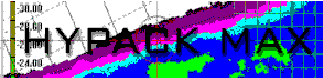
GCT uses HYPACK™,
HYSWEEP™ Hydrographic survey software and Skynet™, GCT's proprietary
hydrographic survey software.
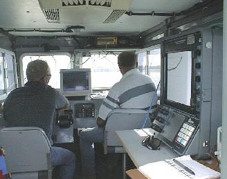
HYPACK and
SkyNet, both provide: navigation along predetermined survey lines,
graphical
displays of plan and profile views while surveying, real time coordinate conversions,
data storage and processing. This system is
also capable of on-board map production of surveyed data.
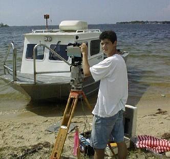
Range Azimuth
System:
GCT's Range Azimuth System, (purchased
in 1989), is comprised of the HYDRO I RANGE AZIMUTH SYSTEM linked with our
TOSHIBA
Laptop Computer. This system provides digital data in X, Y, & Z format at a rate of
0.7 seconds per fix. This data is downloaded directly from the HYDRO I Ship Computer to
the Laptop Computer which allows unlimited data storage and field verification of survey
data.
|