|
Gustin, Cothern & Tucker |
||
| Land Surveying - Civil Engineering - Hydrographic Surveying - Aerial Surveying | ||
|
Home � Information Reference � Services � Leading Technology � Hydrographic � Surveying � Utility / Route Surveys � Mean High Water Surveys � Civil Engineering � Request A Survey � Feedback � Search Site � Employee Directory |
||
LEADING FIELD TECHNOLOGY
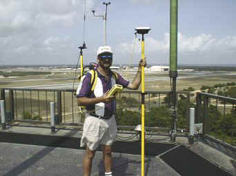
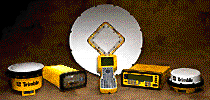
GCT owns 6 Trimble Navigation™(GPS) receivers (3) 4400 GPS Total Stations and (3) 4000SE Receivers. Our GPS receivers have real-time kinematic (RTK) capabilities, and On the Fly (OTF) initialization which enable GCT survey crews to provide very accurate Control, Topographic, As-built and Construction Stake-out surveys. For the client this means significant time and cost savings. Projects have been completed in 1/2 to 1/3 of the time required for a conventional survey. THEN
GCT software technicians have developed a real-time survey system utilizing Differential GPS (DGPS). This system allows Real-time surveys for checking existing features or mapping new features. This system has been used very successfully in Wetlands mapping, GIS mapping, recovery of NGS Control, and physical feature/topbank surveys for the Army Corps of Engineers.
AUTOMATED
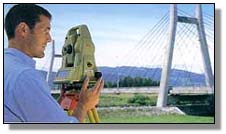
DATA COLLECTION GCT also has conventional survey equipment such as: the Hydro I RangeAzimuth system, DGPS Hydro System, Wild T-1000 w/Tripod Data Systems Data Collection, TopCon total stations w/Tripod Data Systems Data Collection, Wild & Kern 1 second Theodolites andlevels. These automated data collection systems create a seamless survey; from field, to office, to finished product, and minimizes the introduction of human error. GCT brings the depth of experience and strength of resources necessary to provide efficient and accurate surveys. copyright Gustin, Cothern & Tucker, Inc. 1999 |