|
| Gustin, Cothern & Tucker, Inc. offers specialized services
in the establishment of Local Tidal Datum and the determination of Mean High,
Mean Low, Mean Low Low, or Mean High High Water. Surveys of this
nature are required for Hydrographic surveys (Mean Low Low Water as related to
depths for Navigable waterways), and Boundary surveys (Mean High Water (MHW) as
the boundary between state sovereignty land under navigable waters and uplands subject to
private ownership). These surveys often require installation of Tide Staffs or Electronic
water level monitors (pressure and temperature sensors) such as, In-Situ TROLL™ Model
SP4000 pressure and temperature sensors. |
 |
The process for
establishing a tidal datum in an area is determined by the dynamics effecting the flow of
tidal waters at the particular site. A large project may require two or three different
methods and field practices. These methods include Height Difference, Amplitude Ratio,
Range Ratio and Interpolation of Tidal Datum. GCT surveyors access a project and coordinate with the appropriate governmental agency to
determine which methods and procedures to use. In Florida the agency responsible for this
is the "Florida Department of Environmental Protection, Bureau of Surveying and
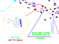
Mapping". A typical Project Flow Diagram in Florida would be as follows:
surveyors access a project and coordinate with the appropriate governmental agency to
determine which methods and procedures to use. In Florida the agency responsible for this
is the "Florida Department of Environmental Protection, Bureau of Surveying and
Mapping". A typical Project Flow Diagram in Florida would be as follows: |
MHW data request and conditional
approval of methodology (10 days max) |
Written Preliminary MHW Procedure approval (30
days max) |
Perform and submit water level observations
and computations |
Receive FDEP approval of MHW study data. |
| Perform survey work to locate MHW
contour line at project site |
Submit check prints of survey for review and
FDEP File Number |
Submit signed sealed mylar drawings for final
MHW survey approval |
 |
 GCT supervisors and field personnel have
received 30 hours of training in Mean High Water Surveying: Field Practices and
Data Processing. This course training is approved by the "Florida Department
of Business and Professional Regulations" and the "Florida Board of Professional
Surveyors and Mappers". GCT supervisors and field personnel have
received 30 hours of training in Mean High Water Surveying: Field Practices and
Data Processing. This course training is approved by the "Florida Department
of Business and Professional Regulations" and the "Florida Board of Professional
Surveyors and Mappers". |
 |
 |
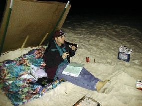
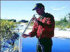
| Staff reading on Gulf of Mexico at
Perdido Key, FL, in February ( 28� F.) |
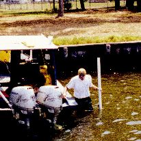
Installation
of In-Situ TROLL™ electronic water level monitor on Pensacola Bay, FL. |
|
|
 |
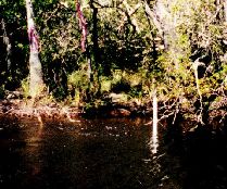 |
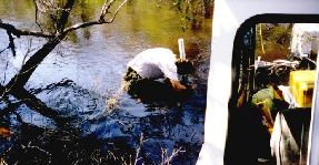
Installation of In-Situ TROLL™ electronic
water level monitor on East Bay River, FL. |
Electronic water
level monitor on East Bay River, FL, w/bench marks. |
| ELECTRONIC WATER
LEVEL MONITOR: |
| Water
Level Measurement. The pressure sensor measures pressure-in kiloPascals (kPA) or
pounds per square inch (PSI), with an accuracy of �0.05% full scale. The TROLL 4000
measures water level and temperature changes with unprecedented accuracy and reliability.
Pressure readings are fully compensated for barometric fluctuations and changes in
temperature. The TROLL can store 16 separate data collection schedules, and at least
100,000 data points at a linear measurement rate with intervals from 3 seconds to one week
between readings. |

 |
 |
copyright Gustin, Cothern
& Tucker, Inc.2000
|
|